Effects of Climate and Anthropogenic Drivers on Surface Water Area in the Southeastern United States
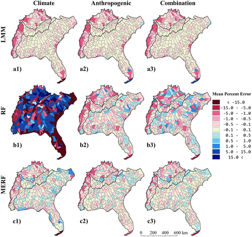 Figure 3 from the publication. “Overall Mean Percent Error at the HUC level for all nine models. Light to dark pink HUCs indicate an underestimation of percent surface water area with the magnitude of the underestimation increasing with the hue. Light to dark blue HUCs indicate an overestimation of percent surface water area with the magnitude of the overestimation increasing with the hue.”
Abstract
Surface water is the most readily accessible water resource and provides an array of ecosystem services, but its availability and access are stressed by changes in climate, land cover, and population size. Understanding drivers of surface water dynamics in space and time is key to better managing our water resources. However, few studies estimating changes in surface water account for climate and anthropogenic drivers both independently and together. We used 19 years (2000–2018) of the newly developed Dynamic Surface Water Extent Landsat Science Product in concert with time series of precipitation, temperature, land cover, and population size to statistically model maximum seasonal percent surface water area as a function of climate and anthropogenic drivers in the southeastern United States. We fitted three statistical models (linear mixed effects, random forests, and mixed effects random forests) and three groups of explanatory variables (climate, anthropogenic, and their combination) to assess the accuracy of estimating percent surface water area at the watershed scale with different drivers. We found that anthropogenic drivers accounted for approximately 37% more of the variance in the percent surface water area than the climate variables. The combination of variables in the mixed effects random forest model produced the smallest mean percent errors (mean −0.17%) and the highest explained variance (R 2 0.99). Our results indicate that anthropogenic drivers have greater influence when estimating percent surface water area than climate drivers, suggesting that water management practices and land-use policies can be highly effective tools in controlling surface water variations in the Southeast.
Mollie D. Gaines
Postdoctoral Research Scholar
I am a Postdoctoral Research Scholar in the Department of Forestry and Environmental Resources at North Carolina State University.
Mirela G. Tulbure
Professor
I am a Professor with the Center for Geospatial Analytics at North Carolina State University (NCSU).
Vini Perin
PhD Student
My research interests include surface water, agriculture, irrigation, remote sensing and hydrological modeling.