Monitoring Small Water Bodies Using High Spatial and Temporal Resolution Analysis Ready Datasets
 Graphical abstract of paper
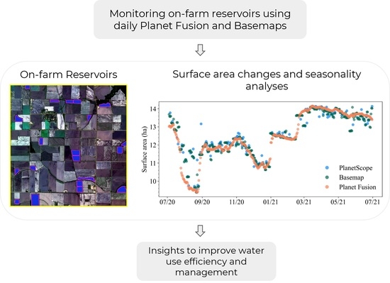
Abstract
Basemap and Planet Fusion—derived from PlanetScope imagery—represent the next generation of analysis ready datasets that minimize the effects of the presence of clouds. These datasets have high spatial (3 m) and temporal (daily) resolution, which provides an unprecedented opportunity to improve the monitoring of on-farm reservoirs (OFRs)—small water bodies that store freshwater and play important role in surface hydrology and global irrigation activities. In this study, we assessed the usefulness of both datasets to monitor sub-weekly surface area changes of 340 OFRs in eastern Arkansas, USA, and we evaluated the datasets main differences when used to monitor OFRs. When comparing the OFRs surface area derived from Basemap and Planet Fusion to an independent validation dataset, both datasets had high agreement (r2 ≥ 0.87), and small uncertainties, with a mean absolute percent error (MAPE) between 7.05% and 10.08%. Pairwise surface area comparisons between the two datasets and the PlanetScope imagery showed that 61% of the OFRs had r2 ≥ 0.55, and 70% of the OFRs had MAPE <5%. In general, both datasets can be employed to monitor OFRs sub-weekly surface area changes, and Basemap had higher surface area variability and was more susceptible to the presence of cloud shadows and haze when compared to Planet Fusion, which had a smoother time series with less variability and fewer abrupt changes throughout the year. The uncertainties in surface area classification decreased as the OFRs increased in size. In addition, the surface area time series can have high variability, depending on the OFR environmental conditions (e.g., presence of vegetation inside the OFR). Our findings suggest that both datasets can be used to monitor OFRs sub-weekly, seasonal, and inter-annual surface area changes; therefore, these datasets can help improve freshwater management by allowing better assessment and management of the OFRs.
Vini Perin
PhD Student
My research interests include surface water, agriculture, irrigation, remote sensing and hydrological modeling.
Mirela G. Tulbure
Professor
I am a Professor with the Center for Geospatial Analytics at North Carolina State University (NCSU).