Evaluating static and dynamic landscape connectivity modelling using a 25-year remote sensing time series
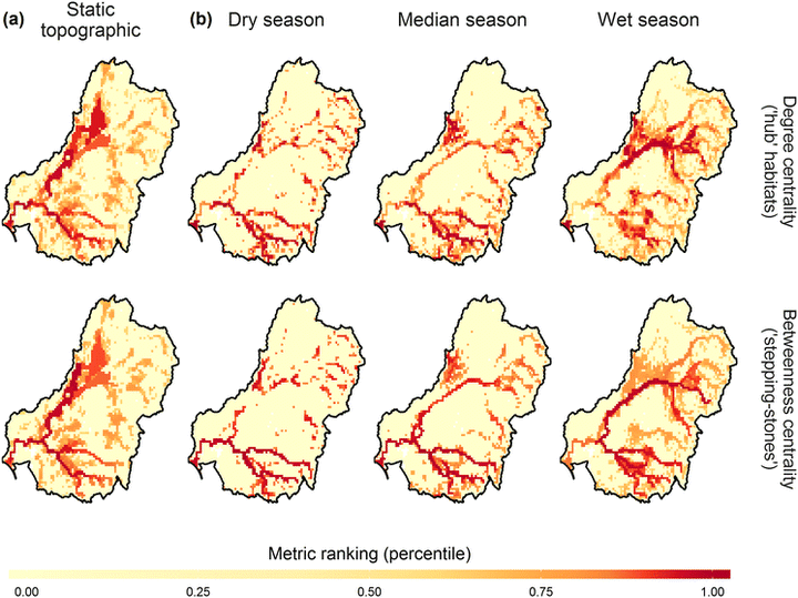 Comparison of the spatial distribution of local degree and betweenness centrality metrics between the (a) static topographic scenario and (b) the driest, median and wettest seasonal time steps across the entire MDB. Red (dark) colours indicate areas ranked highly for degree and betweenness centrality connectivity. Results are shown for a 15,000 m cell size aggregation.
Abstract
Despite calls for landscape connectivity research to account for spatiotemporal dynamics, studies have overwhelmingly evaluated the importance of habitats for connectivity at single or limited moments in time. Remote sensing time series represent a promising resource for studying connectivity within dynamic ecosystems. However, there is a critical need to assess how static and dynamic landscape connectivity modelling approaches compare for prioritising habitats for conservation within dynamic environments. To assess whether static landscape connectivity analyses can identify similar important areas for connectivity as analyses based on dynamic remotely sensed time series data. We compared degree and betweenness centrality graph theory metric distributions from four static scenarios against equivalent results from a dynamic 25-year remotely sensed surface-water time series. Metrics were compared at multiple spatial aggregation scales across south-eastern Australia’s 1 million km2 semi-arid Murray–Darling Basin and three sub-regions with varying levels of hydroclimatic variability and development. We revealed large differences between static and dynamic connectivity metric distributions that varied by static scenario, region, spatial scale and hydroclimatic conditions. Static and dynamic metrics showed particularly low overlap within unregulated and spatiotemporally variable regions, although similarities increased at coarse aggregation scales. In regions that exhibit high spatiotemporal variability, static connectivity modelling approaches are unlikely to serve as effective surrogates for more data intensive approaches based on dynamic, remotely sensed data. Although this limitation may be moderated by spatially aggregating static connectivity outputs, our results highlight the value of remotely sensed time series for assessing connectivity in dynamic landscapes.
Robbi Bishop-Taylor
PhD Student
Robbi currently works for Geoscience Australia’s earth observation team, which can be seen here.
Mirela G. Tulbure
Professor
I am a Professor with the Center for Geospatial Analytics at North Carolina State University (NCSU).
Mark Broich
Postdoctoral Research Fellow
Played a central research role on the Geospatial Analysis for Environmental Change team and had a key role in building the GAEC lab.