Modeling multidecadal surface water inundation dynamics and key drivers on large river basin scale using multiple time series of Earth-observation and river flow data
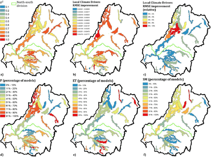 Figure 4 from the publication, “Model statistics for the floodplain-lake category across the Murray-Darling Basin, averaged over grid cells that used the same modeling gauge. Shown are zonal averages of (a) r 2 , (b) the absolute, and (c) relative improvement in RMSE after adding the local climate driver variables and the percentage of models, for which adding (d) P, (e) ET, and (f) SM led to RMSE improvement. For better illustration of patterns in the modeling results, the symbology was adapted individually for each result metric. "
Abstract
Periodically inundated floodplain areas are hot spots of biodiversity and provide a broad range of ecosystem services but have suffered alarming declines in recent history. Despite their importance, their long-term surface water (SW) dynamics and hydroclimatic drivers remain poorly quantified on continental scales. In this study, we used a 26 year time series of Landsat-derived SW maps in combination with river flow data from 68 gauges and spatial time series of rainfall, evapotranspiration and soil moisture to statistically model SW dynamics as a function of key drivers across Australia’s Murray-Darling Basin (∼1 million km2). We fitted generalized additive models for 18,521 individual modeling units made up of 10 × 10 km grid cells, each split into floodplain, floodplain-lake, and nonfloodplain area. Average goodness of fit of models was high across floodplains and floodplain-lakes (r2 > 0.65), which were primarily driven by river flow, and was lower for nonfloodplain areas (r2 > 0.24), which were primarily driven by rainfall. Local climate conditions were more relevant for SW dynamics in the northern compared to the southern basin and had the highest influence in the least regulated and most extended floodplains. We further applied the models of two contrasting floodplain areas to predict SW extents of cloud-affected time steps in the Landsat series during the large 2010 floods with high validated accuracy (r2 > 0.97). Our framework is applicable to other complex river basins across the world and enables a more detailed quantification of large floods and drivers of SW dynamics compared to existing methods.
Media Coverage:
Valentin Heimhuber
PhD Student
Valentin currently works at UNSW as a postdoctoral researcher in hydrology. See what he is up to now here.
Mirela G. Tulbure
Professor
I am a Professor with the Center for Geospatial Analytics at North Carolina State University (NCSU).
Mark Broich
Postdoctoral Research Fellow
Played a central research role on the Geospatial Analysis for Environmental Change team and had a key role in building the GAEC lab.