Surface water extent dynamics from three decades of seasonally continuous Landsat time series at subcontinental scale in a semi-arid region
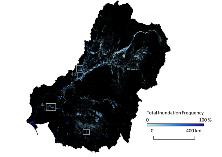 Flooding frequency (the number of times a pixel was flagged as flooded divided by the number of cloud-free observations per pixel expressed as 0 to 100%) in the Murray-Darling Basin for the entire time series (1986-2011).
Abstract
Seasonally continuous long-term information on surface water and flooding extent over subcontinental scales is critical for quantifying spatiotemporal changes in surface water dynamics. We used seasonally continuous Landsat TM/ETM + data and generic random forest-based models to synoptically map the extent and dynamics of surface water and flooding (1986–2011) over the Murray–Darling Basin (MDB). The MDB is a large semi-arid basin with competing demands for water that has recently experienced one of the most severe droughts in the southeast of Australia. We used a stratified random probability sampling design with 500 sample pixels each observed across time to assess the accuracy of the surface water maps. We further developed models to map flooded forest at a riparian site that experienced severe tree dieback. Water indices and bands 5 and 6 were among the top 10 explanatory variables most important for mapping surface water. Surface water extent per season per year showed high inter-annual and seasonal variability, with low extent and variability during the Millennium Drought (1999–2009). Accuracy assessment yielded an overall classification accuracy of 99.9% (± 0.02% standard error) with 87% (± 3%) and 96% (± 2%) producer’s and user’s accuracy of water, respectively. User’s and producer’s accuracies of water were higher for Landsat 7 than Landsat 5 data. Both producer’s and user’s accuracies of water were lower in wet years compared to dry years. The approach presented here can be further developed for global application and is relevant to areas with competing water demands. Quantifying the uncertainty of the accuracy assessment and providing an unbiased accuracy estimate are imperative steps when remotely sensed products are intended to be used for follow on applications.
Media Coverage:
Mirela G. Tulbure
Professor
I am a Professor with the Center for Geospatial Analytics at North Carolina State University (NCSU).
Mark Broich
Postdoctoral Research Fellow
Played a central research role on the Geospatial Analysis for Environmental Change team and had a key role in building the GAEC lab.