Mapping individual tree health using full-waveform airborne laser scans and imaging spectroscopy: A case study for a floodplain eucalypt forest
Abstract
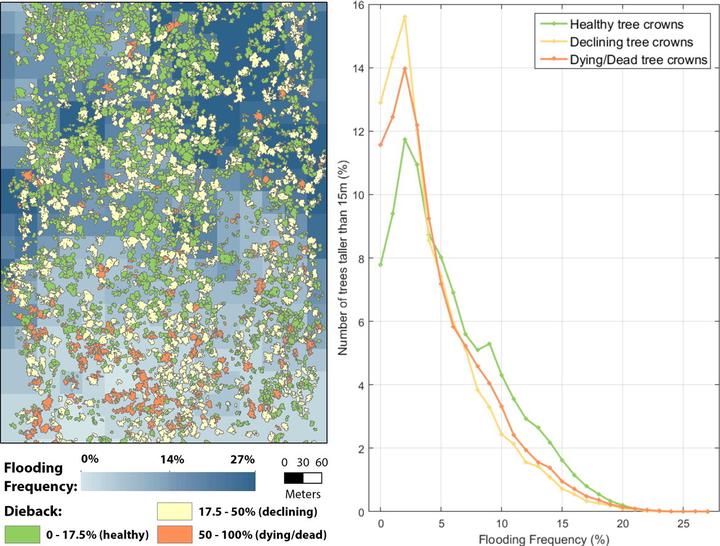
Declining forest health can affect crucial ecosystem functions, such as carbon storage in biomass and soils, the regulation of water regimes, the modulation of regional climate and conservation of biodiversity. Airborne laser scanning (ALS) and imaging spectroscopy (IS) are two potentially complementary remote sensing technologies capable of characterizing and monitoring regional forest health. However, the combined use of ALS and IS data to classify the health of individual trees has not yet been assessed. In this study we propose a new approach utilizing ALS and IS combined to characterize the health of individual trees. Firstly, we applied a recently developed bottom-up individual tree delineation algorithm across a structurally complex floodplain eucalypt forest that has experienced episodes of severe dieback over the past six decades. We further calculated ALS and IS indices for delineated tree crowns and used them as predictor variables in machine learning models. We trained and evaluated an object-oriented random forest classifier against field-measured tree crown dieback and transparency ratios, as indicators of eucalypt tree health and crown density, respectively. Our results showed that dieback levels of individual trees can be classified using ALS and IS with an overall accuracy of 81% and a kappa score of 0.66, while the classification of tree crown transparency levels had an overall accuracy of 70% and a kappa score of 0.5. Returned pulse width, intensity and density related ALS indices were the most important predictors in the tree health classification, as they accounted for > 40% of the variance in the data. At the forest level in terms of dieback, 81.5% of correctly delineated trees were classified as healthy, 12.3% as declining and 6.2% as dying or dead. Dieback occurred primarily in areas that were flooded < 5% of the time, as quantified by Landsat derived flooding frequency (1986–2011). Our results provide a novel application of ALS and IS to accurately classify the health of individual trees in a structurally complex eucalypt forest, enabling us to prioritize areas for forest health promotion and conservation of biodiversity.
Yuri Shendryk
PhD Student
Yuri currently works for Dendra Systems which uses data processing to monitor and restore ecosystems. You can read more about this work here.
Mark Broich
Postdoctoral Research Fellow
Played a central research role on the Geospatial Analysis for Environmental Change team and had a key role in building the GAEC lab.
Mirela G. Tulbure
Professor
I am a Professor with the Center for Geospatial Analytics at North Carolina State University (NCSU).