A comparison of sampling designs for estimating deforestation from Landsatimagery: A case study of the Brazilian Legal Amazon
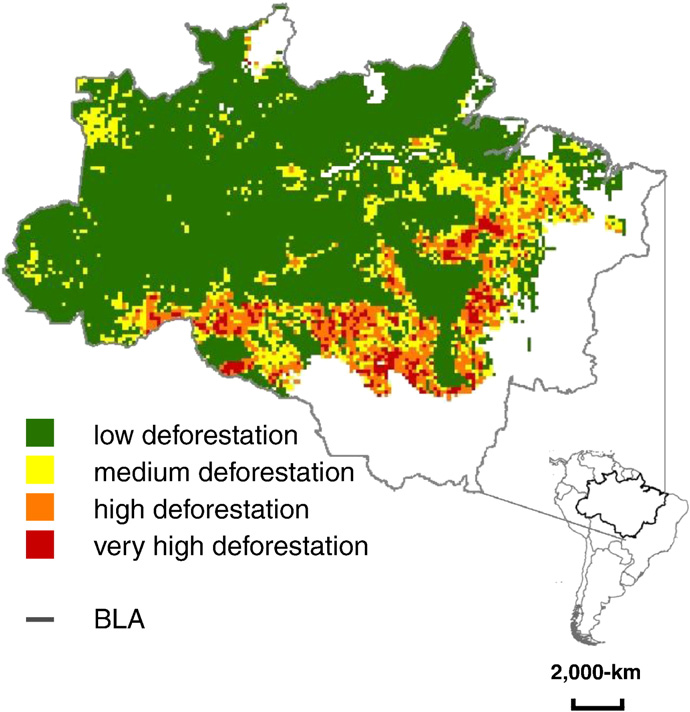 Study area in Brazil, South America: PRODES-mapped area (2000–2005) within the humid tropical forest biome in the Brazilian Legal Amazon (BLA). The study area was partitioned into blocks (18.5-km × 18.5-km) that were assigned to four deforestation strata (shown as green, yellow, orange, and red) based on MODIS-derived deforestation.
Abstract
Three sampling designs —simple random, stratified random, and systematic sampling —are compared onthe basis of precision of estimated loss of intact humid tropical forest area in the Brazilian Legal Amazon from 2000 to 2005. MODIS-derived deforestation is used to partition the study area into strata to intensify sampling within forest clearing hotspots. The precision of the estimator of deforestation area for each designis calculated from a population of wall-to-wall PRODES deforestation data available for the study area. Both systematic and stratified sampling yield smaller standard errors than simple random sampling, and thestratified design has smaller standard errors than the systematic design at each sample size evaluated. The results of this case study demonstrate the utility of a stratified design based on MODIS-derived deforestationdata to improve precision of the estimated loss of intact forest area as estimated from sampling Landsat imagery.
Mark Broich
Postdoctoral Research Fellow
Played a central research role on the Geospatial Analysis for Environmental Change team and had a key role in building the GAEC lab.