Earth Observation Data to support environmental justice: Linking non-permitted Poultry Operations to environmental vulnerability indices
 Credit - Coastal Carolina Riverwatch
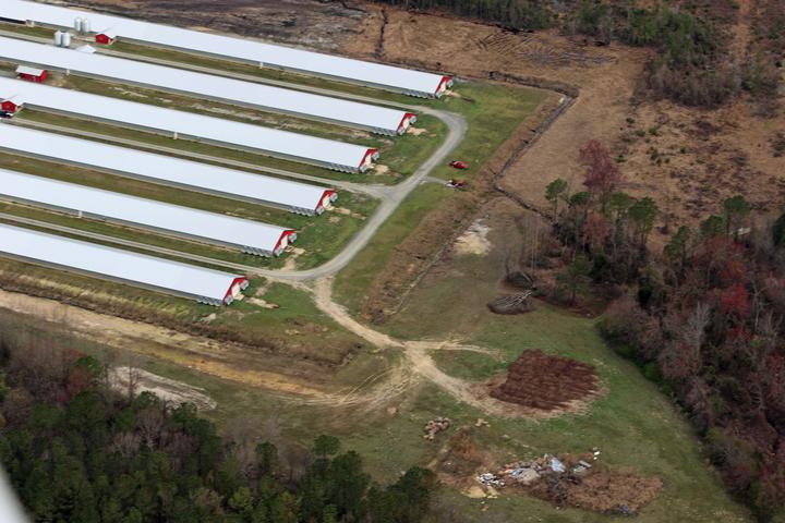
Industrial agriculture disproportionately affects minority, low-income, and Tribal communities, propagating environmental injustice. Concentrated Animal Feeding Operations (CAFOs) apply massive amounts of untreated waste to nearby farmlands. Even though the environmental health impacts of CAFOs are well documented, most studies rely almost exclusively on known CAFO locations from public records, which are incomplete. This is because only CAFOs discharging into US waters need permits; poultry CAFOs generate dry waste and operate without permits.
North Carolina (NC) is the second-highest swine- and the fourth-highest poultry-producing state. The vast majority of NC CAFOs are located in eastern NC, an area with a significant representation of minority, low-income, and indigenous populations with established records of health disparities. The area is experiencing unprecedented flooding from hurricanes, which are projected to increase in frequency and intensity due to climate change.
NC communities have observed a dramatic but poorly documented expansion of poultry CAFOs since the 1997 swine CAFO moratorium. However, the locations of these facilities are essentially unknown, and their environmental impacts are therefore undocumented. Researchers have attempted to manually scan satellite/aerial data for CAFOs or automate detection, but no complete dataset exists. Here, we are using heuristics from the literature on a recently developed poultry CAFO layer derived from deep learning of Earth observations to detect poultry CAFOs. We use aerial survey data collected by the Cape Fear Riverkeeper to ground truth our poultry CAFO dataset. We use these complete poultry CAFO locations to examine how CAFO density correlates with race/income and EPA’s environmental justice indices. This study generates the first full record of non-permitted poultry CAFOs to accurately assess their environmental impacts and intersections with sociodemographic/environmental vulnerabilities.
This project was funded by a North Carolina Center for Human Health and the Environment grant, which ended in 2024. A manuscript describing the work was published in GeoHealth here.
Mirela G. Tulbure
Professor
I am a Professor with the Center for Geospatial Analytics at North Carolina State University (NCSU).
Júlio Caineta
Postdoctoral Research Scholar
I am a Postdoctoral Research Scholar with the Center for Geospatial Analytics website at North Carolina State University (NCSU).
Brooke Cox
She/Her/Hers
Undergraduate Researcher
I am an undergraduate student majoring in Environmental Science at North Carolina State University.