Preprint on geospatial foundation models for global flood mapping
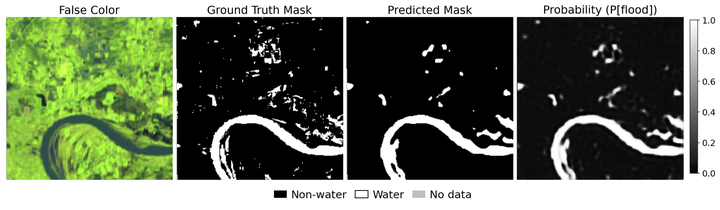
Recent work led by Dr. Tulbure explores geospatial foundation models (GFMs) for global flood mapping. In the study, the team investigated how well GFMs can detect flooding globally. TerraMind was adapted for flood mapping using FloodsNet, a global dataset combining radar and optical satellite imagery, across 85 flood events. Results were compared against both a reference TerraMind setup and a traditional deep-learning architecture.
The experiments showed that the base–unfrozen configuration offered the best balance of accuracy, precision, and recall at lower computational cost. The U-Net trained on FloodsNet achieved the highest recall overall, with slightly lower accuracy and precision than the GFM configurations.
The work highlights the need to shift from model-centric benchmarks toward real-world impact. As GFMs advance rapidly, their environmental and socioeconomic implications deserve equal consideration. In Earth observation, the responsible use of AI ultimately depends on how these tools perform in practical use and how effectively they support decision-making during real flood events.
Check out the summary figures and discussion on Hugging Face and read the preprint here.
Darcy Boast
She/Her/Hers
Undergraduate Researcher
I am an undergraduate student majoring in Environmental Sciences at North Carolina State University.