Paper on mapping urban flooding published
 Graphical abstract
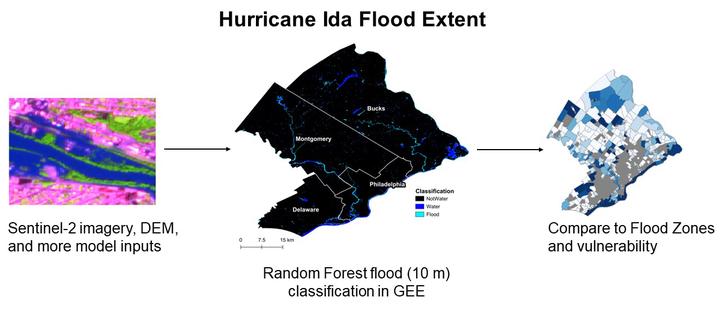
PhD Candidate Rebecca Composto’s first PhD paper has been published in Natural Hazards.
Hurricane Ida brought unprecedented rainfall to the northeast U.S. in September 2021. The flood extent resulting from this rainfall has largely not been mapped. In this study we used Sentinel-2 satellite imagery and a Random Forest machine learning model to map floods in southeastern Pennsylvania (Philadelphia, Montgomery, Delaware, Bucks counties).
Flooding in urban areas are routinely understudied due their complex hydrology. This study addresses this complexity by using multiple datasets in addition to satellite imagery as inputs to the model. This study also created a novel flood extent map for urban counties that did not have one. Now emergency planners, city planners, and every day residents can use the flood extent map to prepare for future flood events.
Read the full article here.
Get the data:
- See the research in action in an interactive map displaying the flood extent, roads, FEMA flood zones and more.
- Get the flood extent on Zenodo.
- Get the code on GitHub.
In the Media:
- NC State Press Release.
- PreventionWeb Post (knowledge sharing platform for disaster risk reduction).
Rebecca Composto
PhD Candidate
I am a PhD student with the Center for Geospatial Analytics at North Carolina State University.