Flood Research Featured by NASA
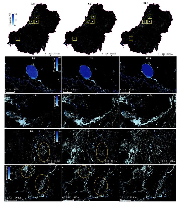 A comparison of surface water and flooding events in Murray Darling Basin located in Australia caught by Landsat 8, Sentinel 2, and the HLS combination. Figure courtesey of Tulbure et al., 2022
NASA brought attention to research done by the Geospatial Analysis for Environmental Change Lab, as posted about here . This research is part of our work with NASA and the resulting publication, Can we detect more ephemeral floods with higher density harmonized Landsat Sentinel 2 data compared to Landsat 8 alone? , was accepted on January 28, 2022 in ISPRS Journal of Photogrammerty and Remote Sensing.
Social Media Buzz:
Time is of the Essence When Monitoring Dryland Floods
— NASA Landsat Program (@NASA_Landsat) September 28, 2022
More frequent satellite observations, such as those of the Harmonized #Landsat Sentinel-2 (HLS) dataset, help capture flood dynamics in regions experiencing short-lived, ephemeral flooding.
Details: https://t.co/Cp5GZoadQH pic.twitter.com/zRUO9Ae3VI
Floods 🌊are deadly; satellite data can track them 🛰
— Dr. Mirela G. Tulbure 🛰 🌎 + 🐍 + 🌊 (@MirelaGTulbure) September 20, 2022
Great news brief by @NASA_Landsat featuring our @NASA funded work showing that we need frequent satellite observations such as NASA’s Harmonized #Landsat - #Sentinel 2 data to quantify #floods: https://t.co/Bdb3V8o8NQ pic.twitter.com/Qu5thz3qtf
Bibliographic Citation
Tulbure, M. G., Broich, M., Perin, V., Gaines, M., Ju, J., Stehman, S. V., Pavelsky, T., Masek, J. G., Yin, S., Mai, J., & Betbeder-Matibet, L. (2022). Can we detect more ephemeral floods with higher density harmonized Landsat Sentinel 2 data compared to Landsat 8 alone? ISPRS Journal of Photogrammetry and Remote Sensing, 185, 232-246. https://doi.org/10.1016/j.isprsjprs.2022.01.021
Brooke Cox
She/Her/Hers
Undergraduate Researcher
I am an undergraduate student majoring in Environmental Science at North Carolina State University.