First paper published as part of NASA Terrestrial Hydrology Project
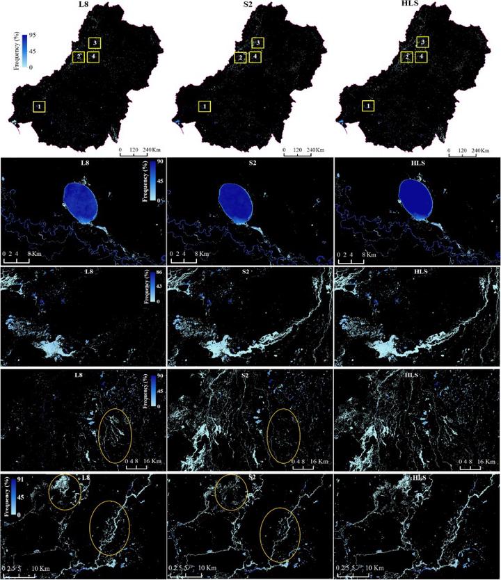 Figure 3 from the publication. “Surface water and flooding frequency using L8 (left), S2 (middle), and HLS data in 2019 in the MDB (top row) and four regions (rows 2–5) to illustrate the difference in L8, S2, and the HLS.”
The paper, Can we detect more ephemeral floods with higher density harmonized Landsat Sentinel 2 data compared to Landsat 8 alone?, was accepted on January 28, 2022 in ISPRS Journal of Photogrammerty and Remote Sensing.
This is the first paper to come from our NASA grant in collaboration with colleagues at UNC Chapel Hill, as posted about here .
The focus of this project is determining whether we can detect more surface water and flooding events using NASA’s Harmonized Landsat Sentinel-2 Surface Reflectance Product than with just Landsat-8 or Sentinel-2 data. The answer appears to be a resounding yes!
Social Media Buzz:
1/11 Can we detect more #floods with NASA’s Harmonized #Landsat - #Sentinel 2 data than with one sensor alone? YES, WE CAN! https://t.co/qrmOqh7AIH
— Dr. Mirela G. Tulbure 🛰 🌎 + 🐍 + 🌊 (@MirelaGTulbure) February 8, 2022
1st paper from our @NASA grant w @uncglobalhydro, @NCSUgeospatial PhD students @_ViniPerin_ & Mollie, @sunyesf @NASAGoddard @UNSW pic.twitter.com/NdoBB4K3gq
Bibliographic Citation
Tulbure, M. G., Broich, M., Perin, V., Gaines, M., Ju, J., Stehman, S. V., Pavelsky, T., Masek, J. G., Yin, S., Mai, J., & Betbeder-Matibet, L. (2022). Can we detect more ephemeral floods with higher density harmonized Landsat Sentinel 2 data compared to Landsat 8 alone? ISPRS Journal of Photogrammetry and Remote Sensing, 185, 232-246. https://doi.org/10.1016/j.isprsjprs.2022.01.021
Brooke Cox
She/Her/Hers
Undergraduate Researcher
I am an undergraduate student majoring in Environmental Science at North Carolina State University.