Vini's 3rd PhD paper on daily monitoring on-farm reservoirs using the next generation of analysis-ready datasets, Planet Fusion and Planet Basemap is out
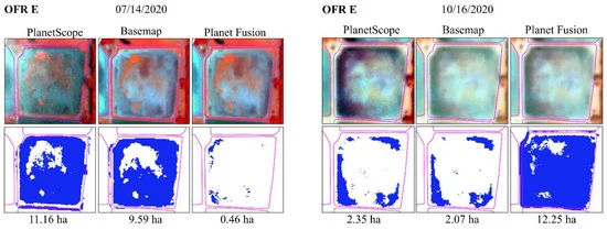 From Figure 10 in the paper: " OFR E (see Table 2) PlanetScope, Basemap, and Planet Fusion false-color composites (blue: red, green: green, and red: NIR) and the surface water classification for 14 July 2020 and 16 October 2020."
“Monitoring Small Water Bodies Using High Spatial and Temporal Resolution Analysis Ready Datasets” was accepted to Remote Sensing in December 2021.
Vini’s 3rd paper assessed the usefulness of the Basemap and Planet Fusion datasets in monitoring sub-weekly surface area changes of 340 on-farm reservoirs in eastern Arkansas, USA. Findings suggest that both datasets can be used to monitor OFRs sub-weekly, seasonal, and inter-annual surface area changes, improving freshwater management by allowing better assessment and management of the OFRs.
Social Media Buzz:
Daily monitoring on-farm reservoirs using the next generation of analysis ready datasets, Planet Fusion and Planet Basemap provided by @planet.
— Vinicius Perin (@_ViniPerin_) December 28, 2021
Thanks @planet, @NASA, @NCSUgeospatial and @MirelaGTulbure for all the support!https://t.co/pLUMteeICw pic.twitter.com/RPrdlHGvjs
Bibliographic Citation
Perin, V., Roy, S., Kington, J., Harris, T., Tulbure, M.G., Stone, N., Barsballe, T., Reba, M., & Yaegar, M.A.. 2021. Monitoring Small Water Bodies Using High Spatial and Temporal Resolution Analysis Ready Datasets. Remote Sensing, 13(5176). https://doi.org/10.3390/rs13245176
Brooke Cox
She/Her/Hers
Undergraduate Researcher
I am an undergraduate student majoring in Environmental Science at North Carolina State University.