Welcome to the Geospatial Analysis for Environmental Change (GAEC) Lab!
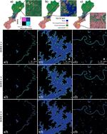
We are a group of dynamic geospatial scientists working on quantifying surface water and flooding dynamics and flood damage using AI algorithms and time series of Earth observation data, at sub-continental to global scales.
Research Interests
Surface Water
Understand surface water dynamics
Remote Sensing
General research topics related to remote sensing
Flooding
Map flooding events using AI algorithms and quantify flood damage